As Sound Transit prepares to wrap up environmental review on the West Seattle Link Extension (WSLE) project, the City of Seattle is starting to plan for how riders will be able to access the planned light rail line via walking and biking. With construction slated to start as soon as 2027, the Seattle Department of Transportation (SDOT) is starting to develop street concept plans that will be implemented as part of station construction work, reallocating space to better match how Sound Transit expects riders to access trains.
This summer, SDOT was awarded a $5.4 million federal grant through the Puget Sound Regional Council to plan for station access around the four planned WSLE stations, at SoDo, Delridge, Avalon, and Alaska Junction. Along with the street concept plans, the grant application offers insight into what projects the City is specifically eyeing. This doesn’t include other projects in the neighborhood planned over the next decade that will undoubtedly have an impact on light rail access, including potential bike lanes along 35th Avenue SW or Fauntleroy Way SW.
“Transformative impacts will accompany WSLE stations in each neighborhood, with significant growth in walking, biking, and crossing streets around stations – including streets historically prioritized for vehicle mobility, rather than safety and comfort for people walking and biking to transit,” the grant application states. “Sound Transit projects approximately 7,000 people will access the new stations via non-motorized modes and 20,000 will access stations by bus transfers – requiring them to briefly become pedestrians while moving between their bus stop and the station entrance.”
In the past, Seattle has adopted streetscape concept plans for individual neighborhoods, including in locations where light rail stations were planned, but this effort takes that to the next level and ensures that all of West Seattle’s stations are captured. What’s missing is how this plan ties into the City’s broader work to create a network, ensuring that these upgrades don’t remain only in isolation.
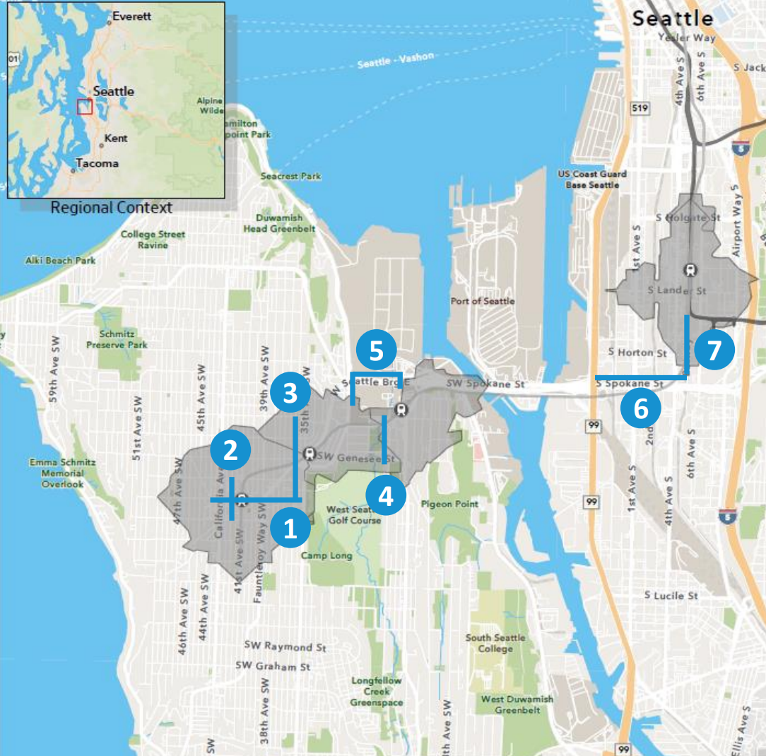
Alaska Junction – Alaska Street
As the front door for the Alaska Junction station, the future of Alaska Street will have a big impact on how easily users can access light rail. Taking a page out of the playbook used for NE 43rd Street in front of U District Station, the proposed streetscape plan includes wider sidewalks, bike lanes, and bus-only lanes in each direction, but no general purpose traffic allowed on the street between Fauntleroy Way SW and 42nd Avenue SW. Drivers on 42nd Avenue SW would be able to turn right onto Alaska and head west to California Avenue SW only.
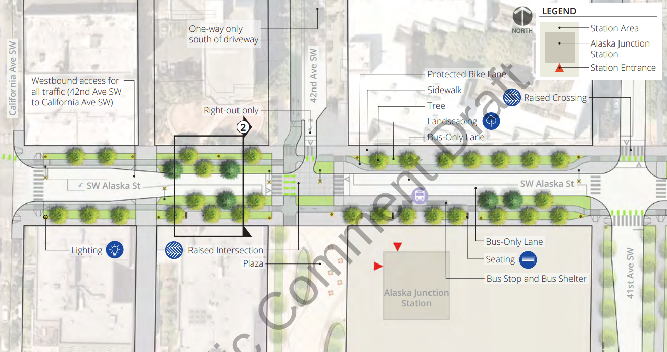
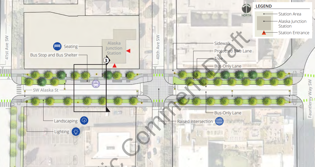
If implemented, the bike lanes along Alaska could seamlessly connect with facilities on Fauntleroy Way SW. However, the status of multimodal improvements on that street is up in the air. A full boulevard plan including a tree-lined median and protected bike lanes had been ready to be implemented by 2015’s Move Seattle Levy, but Mayor Jenny Durkan put the project on hold in 2018 pending a final light rail alignment, worrying Link construction could end up tearing up a freshly repaved street a few years after completion.
Seattle’s next transportation levy, in front of voters in November, does include a Fauntleroy Way repaving project, but it’s still not clear if or when the full vision for the street can be implemented.
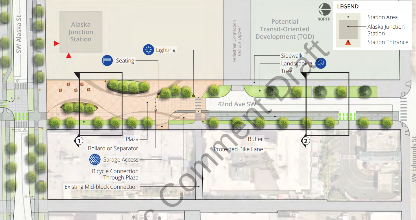
Alaska Junction – 42nd Avenue SW
Envisioned as the main north-south corridor for people accessing Alaska Junction station via walking and biking, the plans for 42nd Avenue SW include a large plaza acting as a traffic diverter south of Alaska Street, with a 12-foot two-way bike facility along the plaza’s west edge. The bike lanes would extend the entire block, transitioning to the existing West Seattle neighborhood greenway south of Edmunds Street.
The city is also planning to add space for buses to layover midblock between Alaska and Edmunds Street off 42nd Avenue SW, a facility that would also function as a “pedestrian connector” — though it’s a bit unclear how that would work at this point.
Avalon Station – 36th Avenue SW/SW Genesee Street
The current limbo of the Fauntleroy Way project weighs heavily on Avalon Station, which is set to directly front onto Fauntleroy. Clarifying Fauntleroy Way plans will be essential to access planning for Avalon. For now, SDOT’s streetscape plans focus on 36th Avenue SW and SW Genesee Street. Already a neighborhood greenway, the vision for 36th is a multi-use trail that connects through Genesee to Fauntleroy, with a raised intersection at the conflict points. A current patch of grass where the angled streets meet would become a plaza with public seating.
On Avalon Way, the plan includes a two-way bike facility along the north side of the street for anyone trying to access the station.
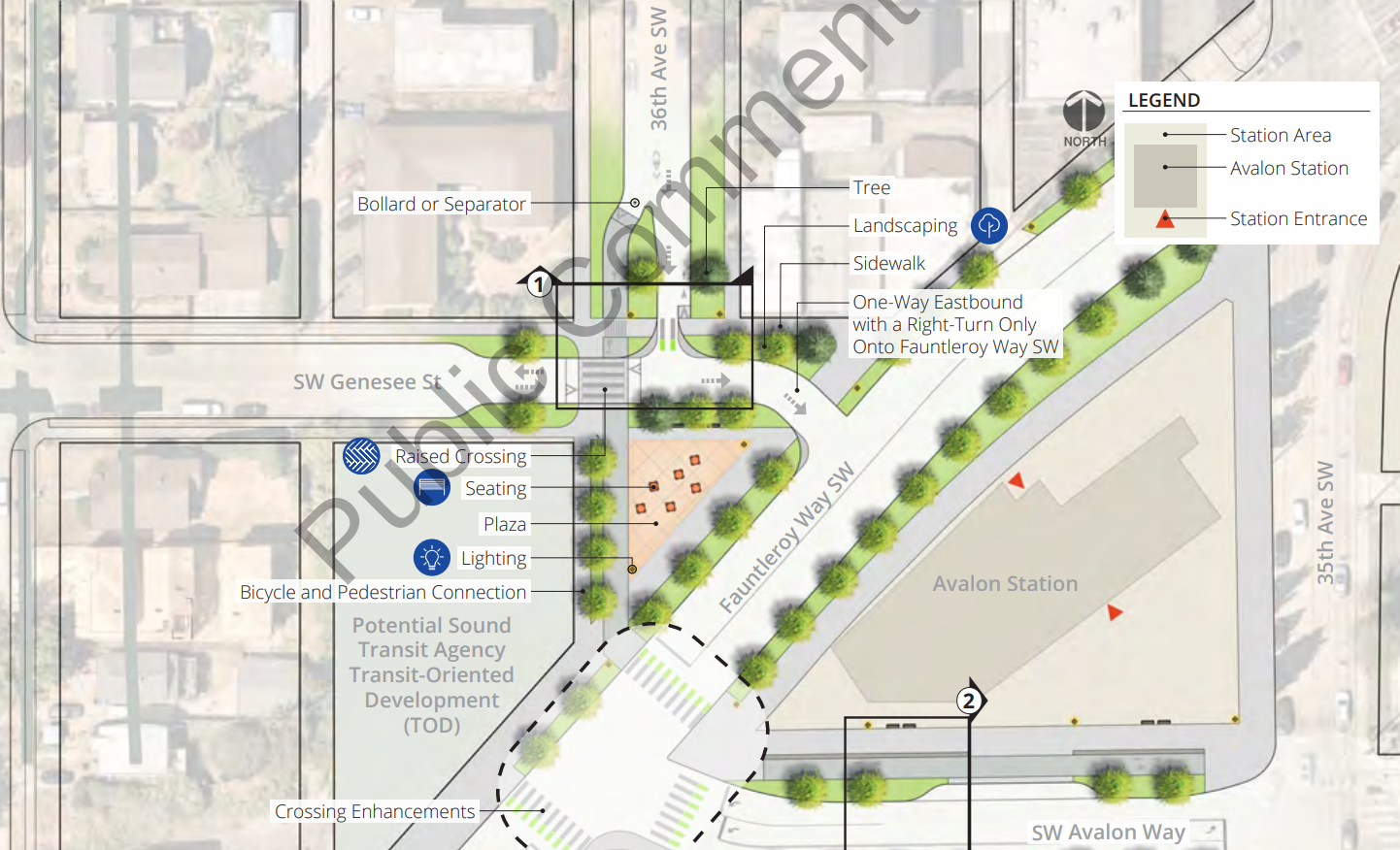
The City also proposes to explore better connections from Avalon Way to the Alki Trail, creating a “a safer and more intuitive trail
crossing” at Spokane Street under the West Seattle Bridge, and adding lighting to the trail itself.
Delridge Station – 26th Avenue SW / SW Charlestown Street
With bus-to-rail transfers at Delridge Station expected to be incredibly high, the draft concepts prioritize transit, with SW Charlestown Street becoming bus-only and providing a way for transit vehicles to loop around from Delridge Way SW. Vehicle access on 26th Avenue SW south of SW Andover Street would no longer be allowed, with a bike and pedestrian path connecting through another street plaza that acts as a traffic diverter.
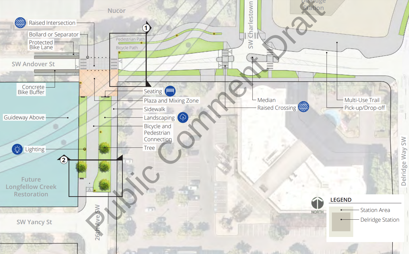
With no bike facilities planned for Delridge Way, station access here is going to depend on the city’s larger neighborhood greenway network at 26th Avenue SW. While the diverter south of Andover will represent a big upgrade for the station’s immediate vicinity, it remains to be seen whether there will be any upgrades to the larger corridor that truly make it an appealing option for a wide range of people biking.
SoDo
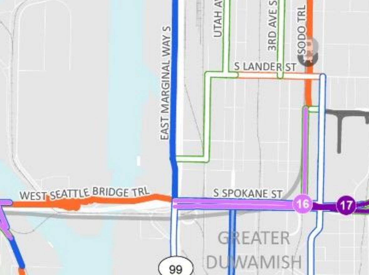
SDOT’s draft streetscape plans do not include West Seattle Link’s SoDo station, which will be built alongside the existing SoDo 1 Line Station and serve as the northern terminus of the line until the completion of Ballard Link, at which time the West Seattle line would continue north to Everett under the “split spine” concept. But the PSRC grant application does provide some details on projects that the City is exploring to increase multimodal access in that area.
An all-ages bike facility along S Spokane Street, underneath the viaduct, would fill in a long-existing network gap, providing access into SoDo from the well-used West Seattle Bridge Trail and East Marginal Way S corridors. At this point, the City is just at the “feasibility analysis” stage of the project, and changes to Spokane Street will almost certainly prove incredibly tricky given the street’s status as a major truck route. But a connection here could tie into the planned Georgetown to Downtown safety project and connect parts of the network that are tantalizingly close together.
The City also wants to explore extending the SoDo Trail all the way to Spokane Street. Today, the trail ends south of S Forest Street.
Comments on the streetscape plan are being accepted through 5pm on Thursday, September 12, with more details about how to submit comments available here. Later this month, Sound Transit will be releasing the Final Environmental Impact Statement (FEIS) for the West Seattle Link Extension, paving the way for the Sound Transit board to approve a final alignment and exact station locations.