Earlier this year, we reported on a newly opened short segment of waterfront bike trail near Colman Dock, the first piece of the long-planned waterfront bike connection. The new stretch between King Street and Yesler Way will be the last one to open to riders for quite a while, with the rest of the trail not slated to open until the rest of the waterfront promenade is finished in early 2024.
While the central waterfront bike trail was being planned, work on a final connection between the aquarium (the northern end of the trail) and the Elliott Bay Trail in Myrtle Edwards Park was left for later. Just last year, the Seattle Department of Transportation (SDOT) identified funds to pay for this final connection.

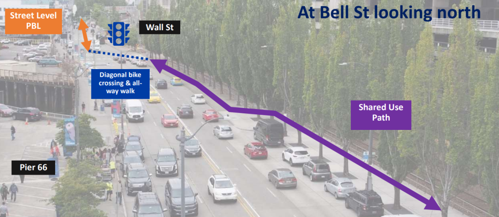
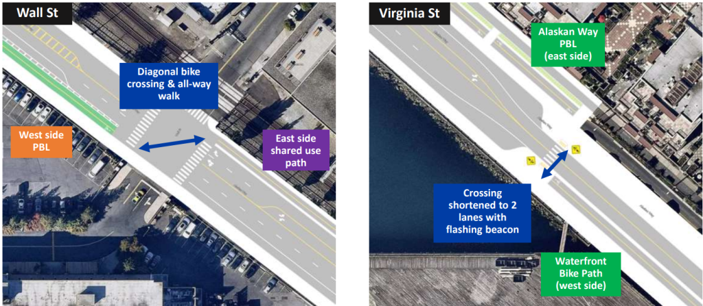
This week, SDOT gave the Seattle Freight Advisory Board an early look at how that final connection will be designed, and the plans so far show a design that will force people on bikes to cross from one side of Alaskan Way to the other two times if they are travelling the full length of the corridor, in order to steer clear of the Port of Seattle’s Pier 66 facility.
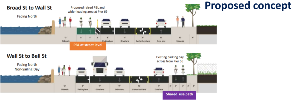
A two-way bicycle facility would cross Alaskan Way at both Virginia Street and Wall Street, preserving parking and loading zones on either side of the street around the cruise terminal facility at Bell Street. The presentation cited five sailings per week during peak season, with “up to 5,000 passengers getting on/off each ship over a 10-hour period.” Pier 66 only has room for one cruise ship at a time.

Forcing people on bikes to switch sides of the street to accommodate vehicle traffic and parking or loading is something SDOT has done elsewhere, including downtown on Pike Street, on 8th Avenue, and in Green Lake. People in cars do not have to switch from one side of the street to the other when using one corridor, but this is considered standard operating procedure for bike lanes. This design is sure to frustrate a lot of people who ride bikes, and diminish the excitement many are feeling around the coming waterfront bike connection. But the pressure to route the bike facility away from one of the Port’s most important revenue generators is going to be intense. On the other hand, many people on bikes will simply not use a bike facility that forces riders to cross a busy road so many times, leading to everyone being frustrated.

Geri Poor, the Port of Seattle’s representative on the Freight Advisory Board, was interested in discussing how the bike facility could possibly be designed to route around Pier 69 as well, where the Argosy Cruises is located. The pier has more frequent sailings, but on an overall basis the foot and vehicle traffic volumes are much lower. Poor was interested in exploring having the northernmost diagonal crossing at Clay Street, which might not make much of a difference; the impact will be from having to do the double crossing in the first place.
The design currently includes a narrow eight foot two-way bike lane between Wall Street and Bell Street where there currently is not a sidewalk along the east side of Alaskan Way. Guidelines established by the National Association of City Transportation Officials (NACTO) state that the ideal width for a two-way cycle track is 12 feet, so SDOT’s design is considerably more narrow. No stretch of the facility would be larger than 10 feet, despite the segment between Virginia Street and Bell Street having room for six lanes of motor vehicle traffic.

SDOT showed early plans for the transition points for riders to switch sides of the street. The southern transition point at Virginia Street includes a narrowed street as planned with the Waterfront project, with bike riders using the crosswalks to transition, while at Wall Street people on bikes would cross diagonally while pedestrians cross all ways.

SDOT is planning an online open house this spring to get feedback on the design, as they work to complete design by next year to open the facility by 2024 to coincide with the rest of the Waterfront project’s grand opening. Having the facility open all at once will be great, but it will be much more important to get the design of the project right. How this project gets improved since this early look will be a serious test of how seriously the SDOT is about making sure this critical bike corridor is the best that it can be.
Ryan Packer has been writing for The Urbanist since 2015, and currently reports full-time as Contributing Editor. Their beats are transportation, land use, public space, traffic safety, and obscure community meetings. Packer has also reported for other regional outlets including Capitol Hill Seattle, BikePortland, Seattle Met, and PubliCola. They live in the Capitol Hill neighborhood of Seattle.


