Earlier this month, Stakeholder Advisory Groups for the Ballard and West Seattle light rail extensions got an update on Level 2 alternatives being evaluated. The updates provided detailed insight to anticipated ridership, mobility connectivity, project costs, and land use compatibility that particular alignment and station alternatives could result in. The update also took a deep look at other dimensions that could be affected by alternatives, such as “constructability” tradeoffs, environmental factors, and demographics served.
Ballard/Interbay Options
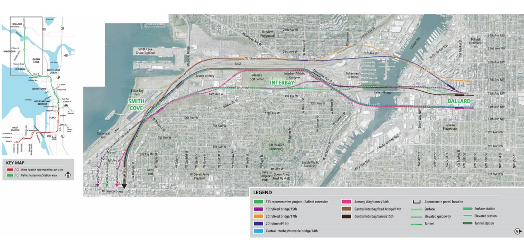
The Level 2 alternatives analysis looked at seven corridor options in addition to the representative project alignment. All of the corridor options stacked up well and all would perform better than the baseline representative project alignment, in large part because the baseline option is a moveable bridge that would essentially stick to 15th Ave NW instead of serving more unique and active destinations.
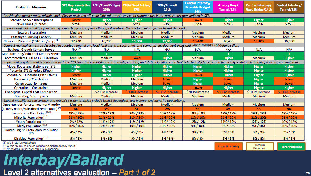
Project costs that exceed $200 million over the baseline option would require a third-party contribution to cover the difference. All three tunnel options would therefore need to procure third-party funding to become a reality since they range from $300 million and $700 million. The most expensive option would create a long bridge span over the railway tracks near 20th Ave W before diving underground to tunnel below Salmon Bay and reach a station near 15th Ave NW.
Perhaps surprisingly, the tunnel options are not the highest performing options in terms of ridership, with two of them in fact performing worse than the baseline option. According to the estimates, the 20th/Fixed Bridge/17th alignment option would command 19,000 daily riders, 1,800 passengers over the baseline option. It would also cost an additional $500 million to do this alignment passing through 20th Ave W in Interbay combined with a fixed bridge over Salmon Bay and station on 17th Ave NW in Ballard.
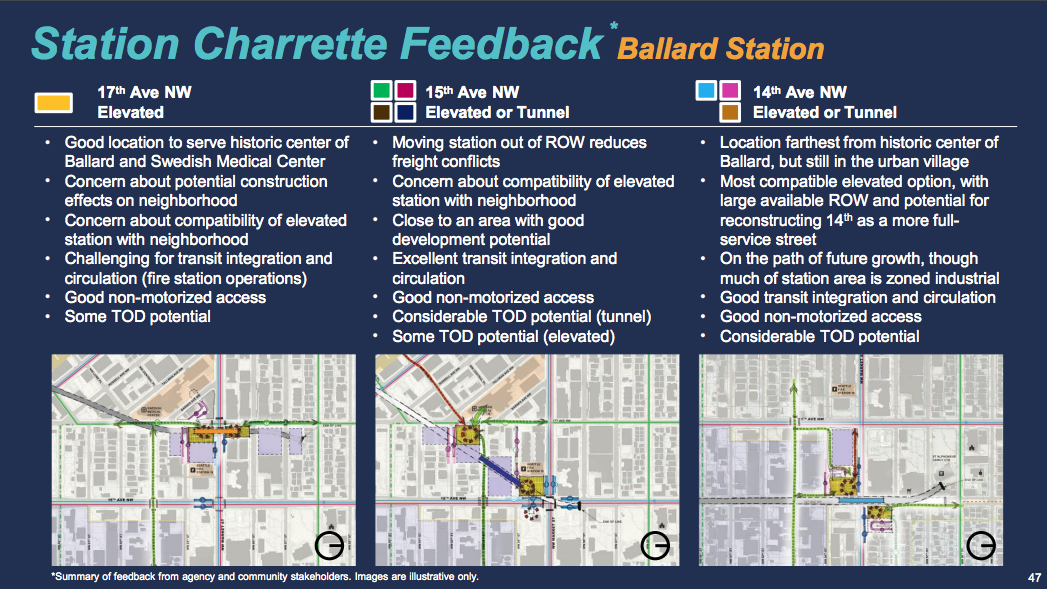
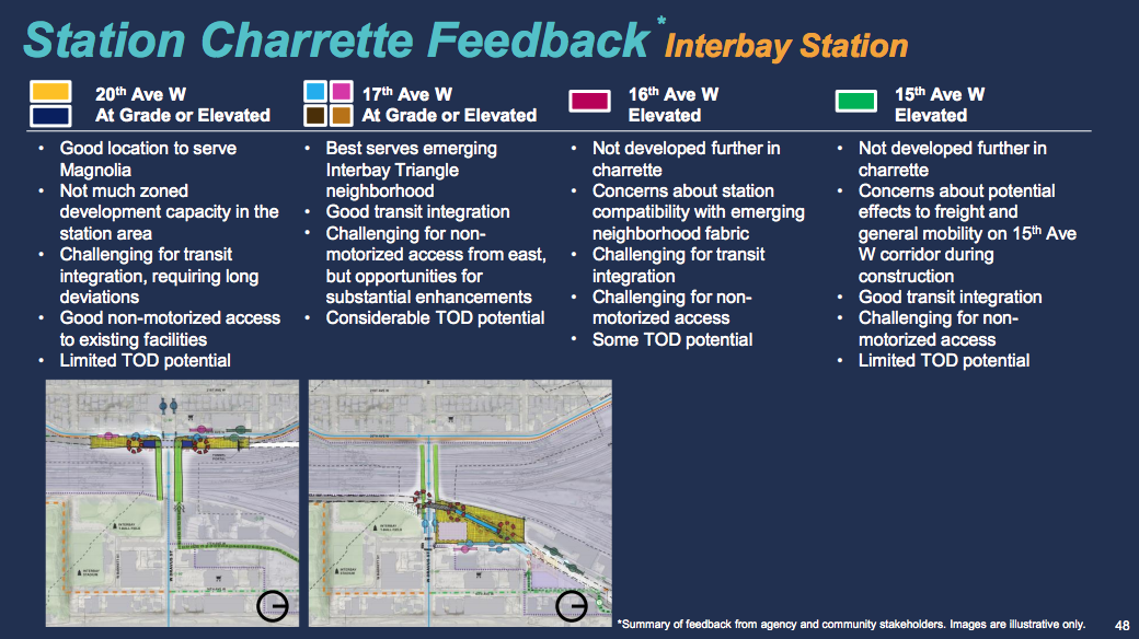
In terms of station planning for Ballard and Interbay, a charrette was conducted to tease out how stations might be located and function. This is, of course, an important dimension to explore since station locations can drive ridership potential and land uses in very important ways. For Ballard, there is a variety of possible station locations that could be situated near 15th Ave NW. Interbay’s central stop is more limited and a question of whether it should be east or west of Burlington Northern Santa Fe railway tracks dividing the neighborhood.
Downtown Options
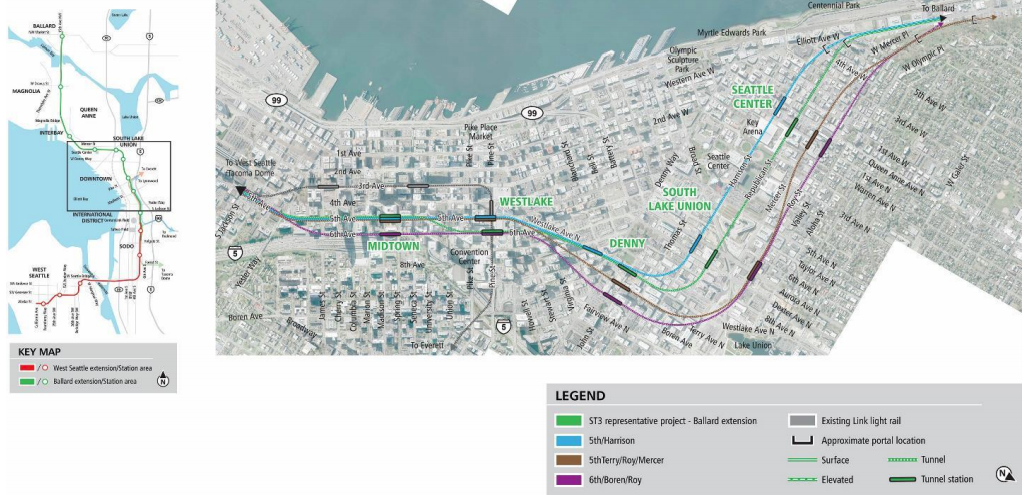
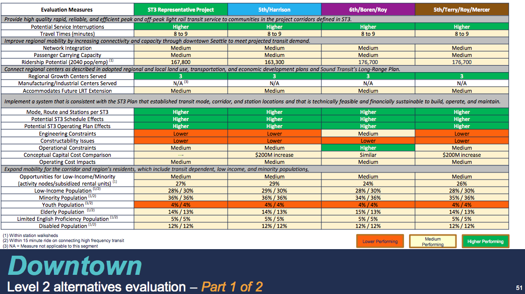
The options through Uptown, South Lake Union, and Downtown are a little narrower with only three alternative corridor options in addition to the representative project alignment. The cost variation between the alternative corridor options is less dramatic than the Ballard and Interbay options. In the case of the 6th Avenue, Boren Avenue, and Roy Street option, costs would be similar to the baseline representative project alignment. The other two alternatives would only be $200 million above the baseline option, which is within the range that Sound Transit might cover the difference.
Both 6th/Boren/Roy and 5th/Terry/Roy/Mercer options would perform noticeably better than the baseline option for ridership with about about 176,700 daily riders projected. That translates to 8,900 more daily passengers than the baseline option. The 5th Avenue and Harrison Street option, however, has the misfortune of both costing $200 million more and generating 4,500 fewer daily passengers than the baseline option.
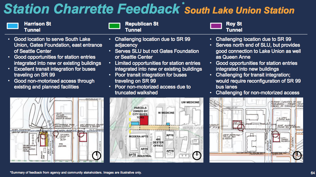
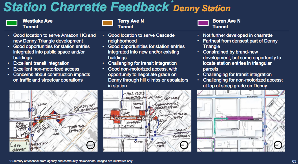
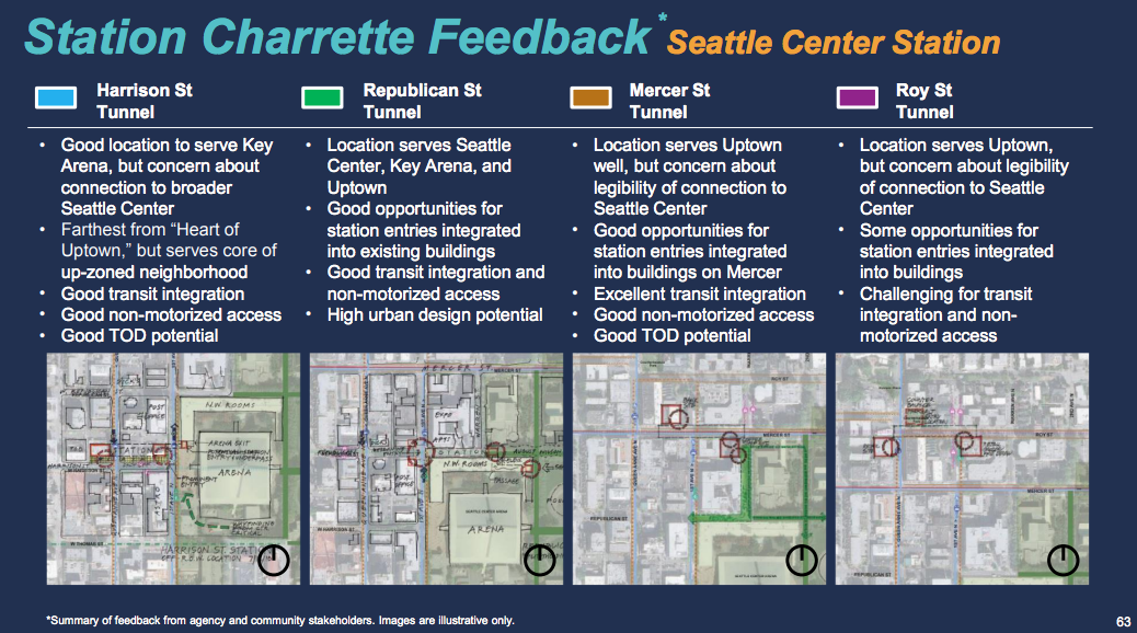
Where to locate the two stations planned for South Lake Union is a bit complex given the fact that a station somewhere near SR-99 and central South Lake Union is so close to the Uptown and Denny locations. However, even those stations have wildly different possibilities depending upon alignment options. A blending of alignments might help to better spread them out while integrating with other transit options, preserving walksheds, and supporting local land uses.
Chinatown-International District/SoDo Options
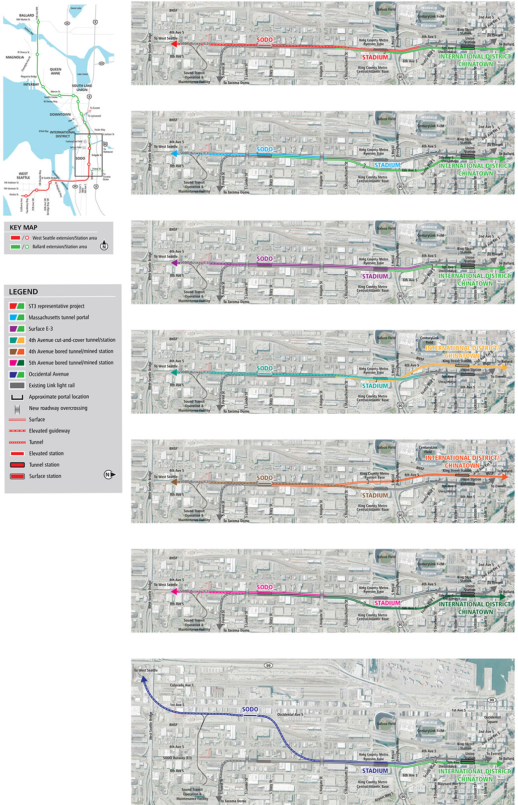
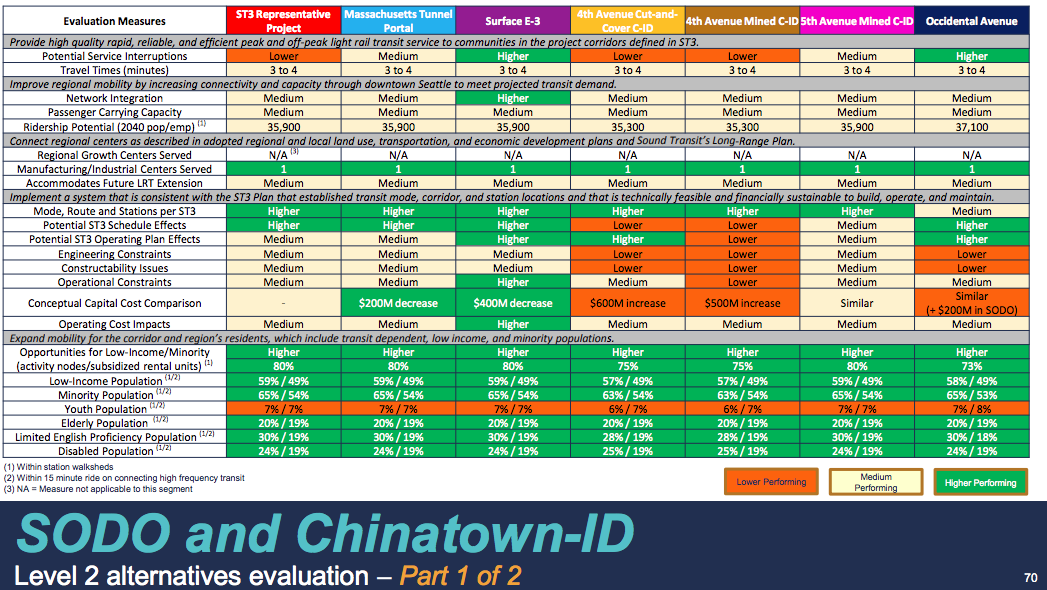
New alternatives were recently added for Level 2 evaluation in the Chinatown-International District/SoDo corridor in response to broad community consensus for bolder ideas. A total of six alternative corridor options have been evaluated in addition to the representative project alignment. The results of these appear fairly mixed cost-wise and construction timing-wise. The overall ridership projections of the options is also fairly close between the alternatives.
In terms of the cost, the alternatives breakdown as follows when compared to the baseline representative project alignment:
- SoDo: $100 million less for the E-3 surface busway option;
- SoDo: $200 million more for the Occidental Ave S option;
- Chinatown-International District: $200 million less for the Massachusetts Tunnel Portal (5th Ave S bored tunnel) option;
- Chinatown-International District: $200 million less for the E-3 surface busway (5th Ave S cut-and-over tunnel) option;
- Chinatown-International District: About the same for the mined 5th Ave S station option;
- Chinatown-International District: $500 million more for the mined 4th Ave S station option; and
- Chinatown-International District: $600 million more for the cut-and-cover 4th Ave S station option.
Under several of these options, a third-party would need to provide additional funding to help cover the budget increases.
Sound Transit estimates that daily ridership on the corridor would total 35,900 under the baseline option. The Occidental Ave S option is the only one that would noticeably affect ridership by adding 1,200 more daily passengers, presumably due to the retail businesses and corporate headquarters of Starbucks nearby on 1st Ave S.
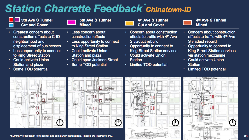
Locating a new station or station complex in Chinatown-International District, however, presents a lot of tradeoffs. Given that there is a major regional and even statewide transportation hub centered on the station area, getting that right will be imperative for future generations that will increasingly rely on transit in the Puget Sound and as far north as Vancouver, British Columbia.
West Seattle Options
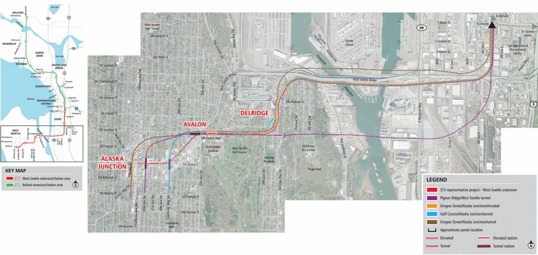
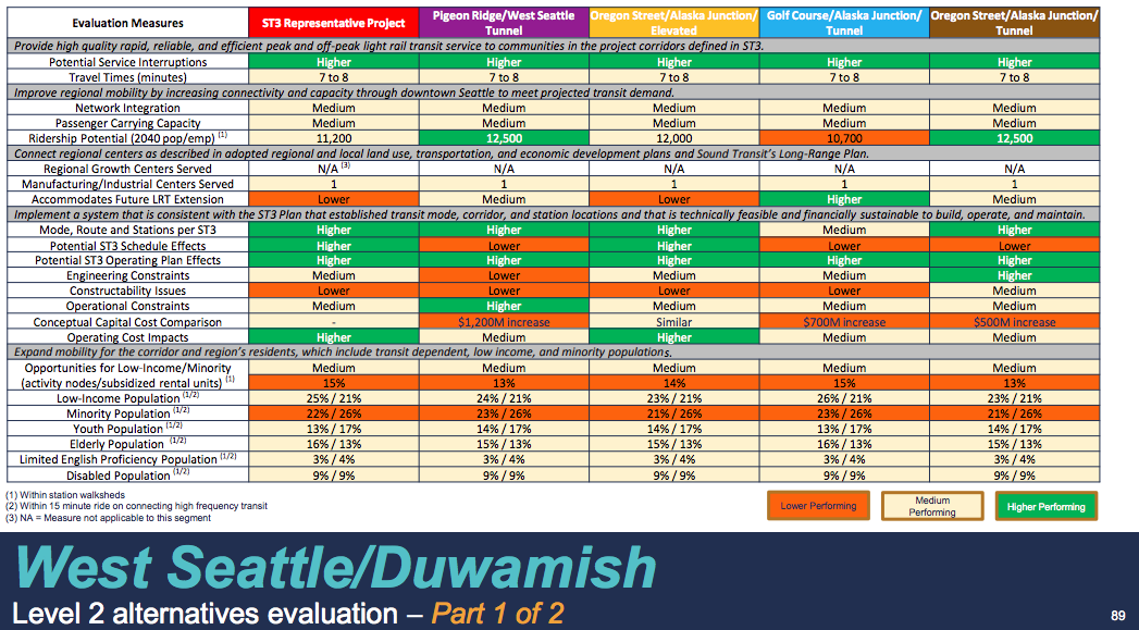
West Seattle had four alternative corridor options evaluated in the Level 2 process in addition to the representative project alignment. Daily ridership under the baseline representative project alignment is projected to be around 11,200 passengers while there is some deviation between the alternatives in ridership estimates. On the high end, the Pigeon Ridge/West Seattle Tunnel and Oregon Street/Alaska Junction/Tunnel options would generate 12,500 daily riders, about 1,300 more than the baseline option. The Golf Course/Alaska Junction/Tunnel would be slightly less than the baseline optionwith 10,700 daily riders.
The Oregon Street/Alaska Junction/Elevated option was comparative cost-wise to the baseline option. But the other alternatives varied wildly with one option, Pigeon Ridge/West Seattle Tunnel, costing an astronomical $1.2 billion more than the already-pricey baseline option. Even the Oregon Street/Alaska Junction/Tunnel would cost $500 million than the baseline option, which will likely mean taking all of the alternative options, except for Oregon Street/Alaska Junction/Elevated, fully off the table. Unlike the unique circumstances for Ballard and Interbay, the lack of ridership and future network advantages of the pricier West Seattle alternatives raises the question of their worthiness for further consideration when the same money could be put to more productive uses like extending light rail deeper into West Seattle, presumably through elevated rail and guideways.
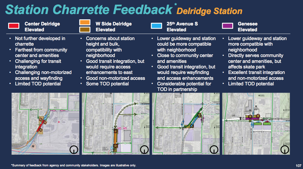
Given the topography, land use and right-of-way makeup, and diverse interests in station locations, the West Seattle alternatives present a wide range possibilities with decidedly clear tradeoffs.
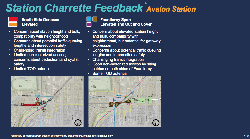
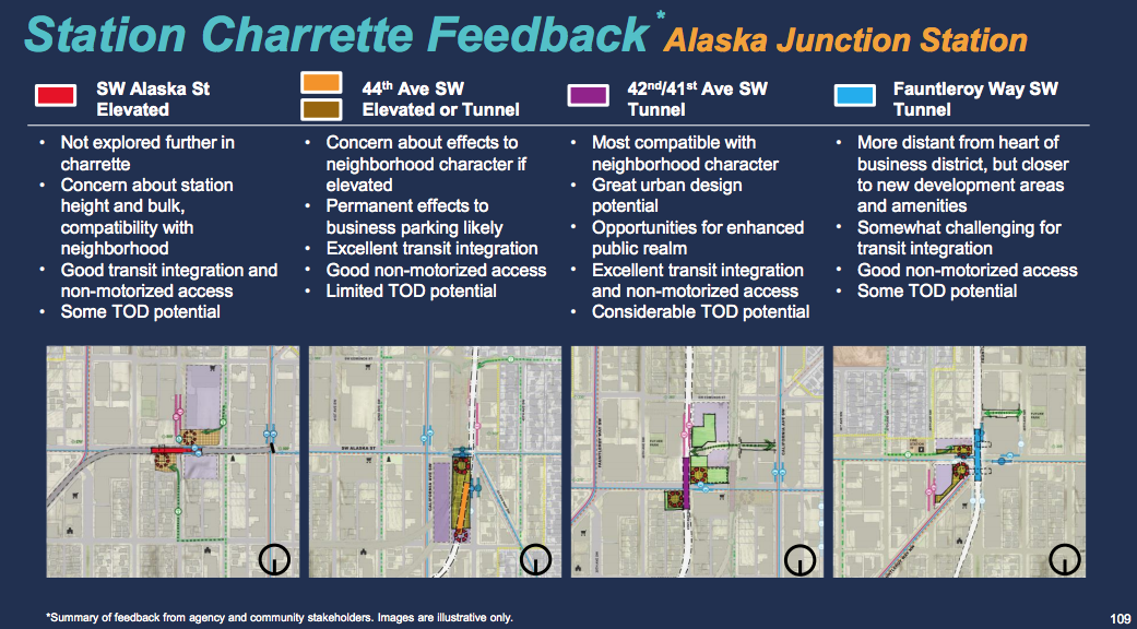
Open for Public Feedback, Next Steps
The Level 2 evaluation results presentation contains a lot more fine-grained details about the alternatives and station area charrettes, which are worth exploring. For now, the public has an opportunity to weigh in on the alternatives online through Sunday (September 23, 2018). The online public open house allows visitors to comment on interactive corridor maps and view rendered profiles of the options. Note that Seattle Subway has published some feedback suggestions. Commenters can pick and choose between options since the ultimate options may be further blended.
Recommendations from the Stakeholder Advisory Groups and Elected Leadership Group should come in the next few weeks, which will determine what will be further evaluated in the Level 3 alternatives analysis process. That latter process should kick off later in October.
Featured image is courtesy of Atomic Taco, Wikimedia Commons.
Sound Transit Explores Options for Chinatown-International District and SoDo
Stephen is a professional urban planner in Puget Sound with a passion for sustainable, livable, and diverse cities. He is especially interested in how policies, regulations, and programs can promote positive outcomes for communities. With stints in great cities like Bellingham and Cork, Stephen currently lives in Seattle. He primarily covers land use and transportation issues and has been with The Urbanist since 2014.

