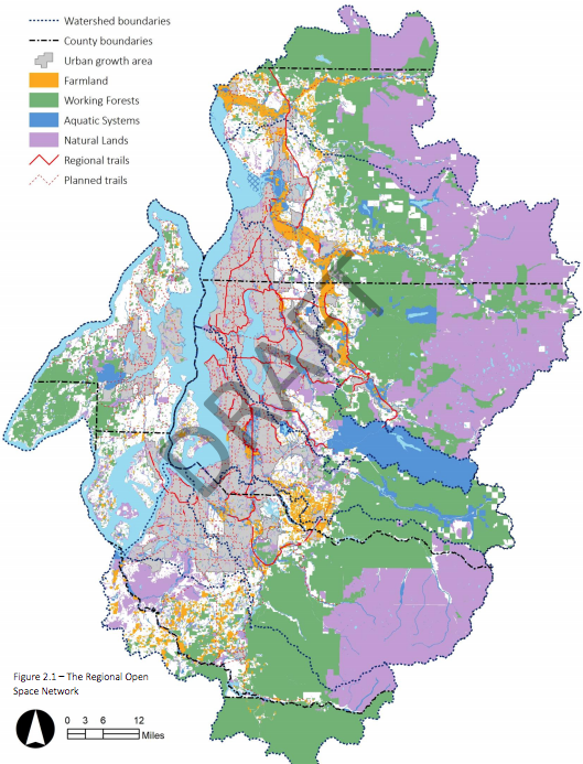
On Tuesday, the Puget Sound Regional Council (PSRC) released a draft plan to guide conservation of open spaces throughout the four-county region in the decades to come. The plan, which is the first of its kind for the region, takes stock of a range of open spaces already existing and ideally preserved in the years ahead through acquisition and designation. The concept of open space is broader than just parks and trails–it also includes farmland, working forests, and other natural lands and aquatic environments in the plan. Comment on the plan is open through March 8th.
Threat of Loss
According to Dave Somers, Snohomish County Executive and President of the PSRC Executive Board, the plan will help realize many key environmental objectives for the region. “The project is the organization’s best opportunity to integrate regional watershed and land use planning to ensure we protect our farms and forests, ensure quality habitat for salmon and other wildlife, safeguard our clean drinking water, and create opportunities for residents to be healthy by exploring and playing outdoors,” he said.
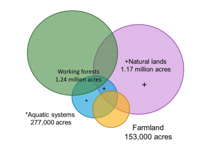
A total of 2.8 million acres of land are considered to be part of the regional open space network. This breaks down into various buckets with the largest as working forests closely followed behind by natural lands, which include urban parks. However, urban parks and trails make up a very small fraction of the total regional open space network.
Most of the 2.8 million acres are in the hands of local, state, and tribal governments, but a considerable amount is not and unfortunately at risk of loss. “Approximately 788,000 acres of the regional open space network are outside of public or tribal ownership,” the plan says. “Of those, there are 126,000 acres of farmland considered to be at risk, 188,000 acres of working forest considered to be at risk, and 133,000 acres of intact habitat in natural lands and aquatic systems considered to be at risk. Combined, these total to 448,000 acres of at-risk open spaces within the regional network.”
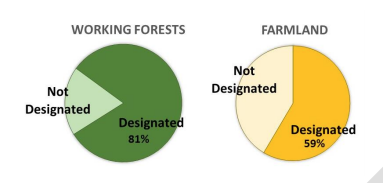
Some lands have special conservation easements protecting them despite being in private ownership. Others have specific land use and zoning designations to ensure that they continue as working farms and forestlands. For instance, the plan reports that about 58% of all farmlands recognized in the open space network have protective regulations in place.
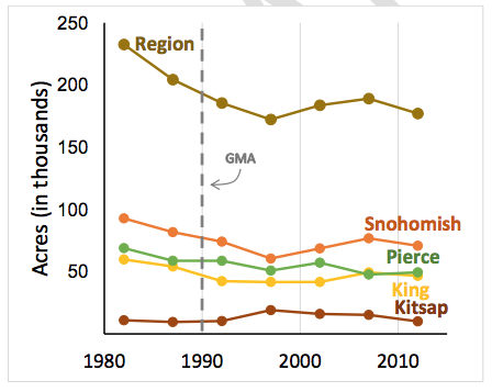
These protections can be helpful in preserving open space lands into the future, but as the diagram suggests above, the threats of loss are real with farmland progressively declining since 1980 despite programs and zoning in place to stem such loss.
Actions and Solutions
The draft plan outlines nine specific actions to preserve the 448,000 acres of open space under at risk of loss:
- “Incorporate open space conservation into all levels of planning. Regional plans, as well as city and county plans, can integrate the regional open space network and prioritize conservation.”
- “Support growth in the right places. Focusing growth in the appropriate locations will continue to reduce development pressure on the regional open space network.”
- “Keep working lands working. Enhance the regional transfer of development rights program, provide support to farmers, and foster farm and forest economies. Maintain agricultural and forestry zoning designations.”
- “Protect remaining key habitat areas. Ensure that critical areas and shoreline regulations are protecting the region’s remaining habitat areas. Land acquisition and/or conservation easements may be needed to provide the best habitat protection, but will require significant conservation funding.”
- “Enhance stewardship on privately owned lands. Implement Public Benefit Ratings Systems. Work with conservation districts and non-profit organizations to provide support to landowners. Explore the use of ecosystem markets to preserve open space services on private lands.”
- “Restore habitat in high value areas. Restoration will be necessary to recover salmon populations. Watershed plans have identified needed restoration projects. Mitigation banking can help fund some restoration.”
- “Coordinate planning among and within agencies and jurisdictions. Many open spaces cross jurisdictional boundaries, requiring coordination to protect them. Many open space lands are important to multiple resource agencies. Maintaining these open space services will require coordination among these different groups.”
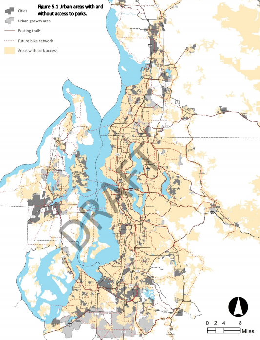
- “Increase connections between people and open space. Ensure all population segments have access to parks and open space. Build out the trail network and provide transit options to regional parks and open space.”
- “Build multi-benefit green infrastructure. Green infrastructure improves stormwater flows, removes pollutants, enhances aquatic systems, and provides recreation and aesthetic opportunities.”
Additionally, a variety of specific tools are suggested to actively protect unprotected lands, such as:
- Transfer of Development Rights (e.g., allowing property owners to sell development rights and purchase programs to buy rights);
- Open space bonds;
- Carbon credits;
- Conservation futures grants levied through property taxes;
- Partnerships with military bases;
- Real estate excise taxes;
- Community forest programs; and
- Other parks levies.
All of these options would allow local jurisdictions to purchase property, create protective open space easements, or set up another protective arrangement. One important caveat by setting aside land through these means, however, is that open space properties generally are not taxed and ultimately result in shifting property tax burdens to other properties within their taxing districts.
So while there is a distortive implication that this can have, protection of open spaces is clearly a high public priority as the region continues to grow over the next 32 years toward 5.8 million residents. Development pressures will only exacerbate unprotected lands to be converted to more intensive uses, which could have deleterious impacts on regional goals to protect and recharge watersheds, reduce and sequester carbon emissions, and foster production of agricultural and natural resources. Planning for a regional open space network is a big step to heading off these negative environmental outcomes.
Nearly Six Million Residents in Central Puget Sound By 2050, PSRC Says
Stephen is a professional urban planner in Puget Sound with a passion for sustainable, livable, and diverse cities. He is especially interested in how policies, regulations, and programs can promote positive outcomes for communities. With stints in great cities like Bellingham and Cork, Stephen currently lives in Seattle. He primarily covers land use and transportation issues and has been with The Urbanist since 2014.

