The Seattle Office of Planning and Community Development (OPCD) released the Final Environmental Impact Statement (FEIS) document today. Mayor Tim Burgess officially released the FEIS at a noon event at Broadway Hill Park.
The final urban village maps with explanations of the decisions are viewable starting around page 113 of this FEIS attachment. The MHA maps (with no explanations) are in Appendix H and start at page 207 of the PDF. An interactive zoning map of the FEIS preferred alternative is also available at this link.
Generally speaking, OPCD has elected to go with a middle path between MHA Alternative 2 and Alternative 3. Alternative 3 included a displacement analysis and shifted some additional growth to neighborhoods with low displacement risk and high opportunity and away from high displacement risk urban villages. Enacting minimal changes in areas with high-risk of displacement remained a core principle for the MHA proposal. Still, OPCD’s final preferred plan keeps some elements of the Alternative 2, which more closely followed the Comprehensive Plan.
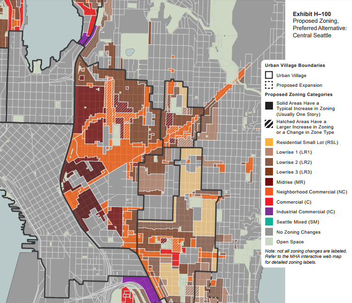
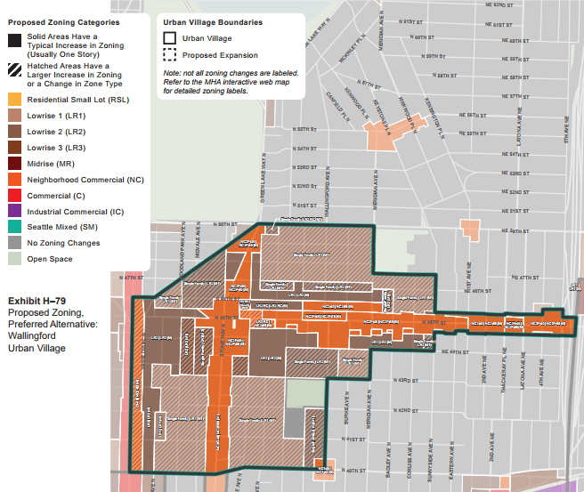
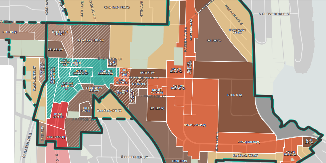
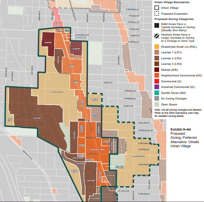
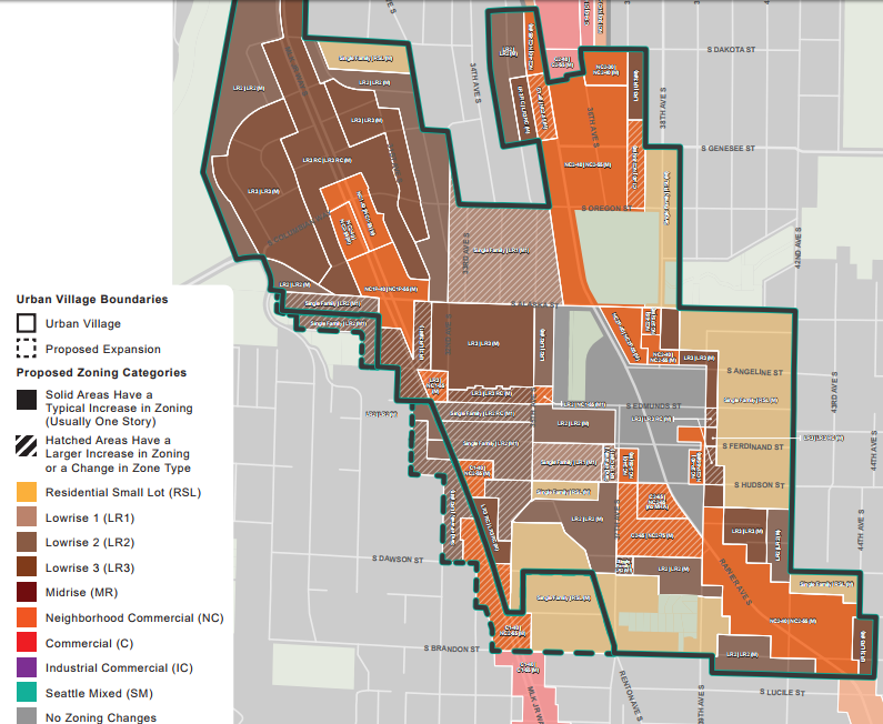
The highest zones will be in First Hill with Highrise 440-foot zoning, followed by Northgate, which is slotted to get some 240-foot zoning near its future light rail station. Low displacement risk neighborhoods like Wallingford generally see heightened upzones over high displacement risk neighborhoods like Rainier Beach, Othello, and Columbia City, the last of which is also a high opportunity area. See the preferred zoning maps below:
Outreach
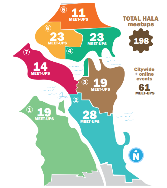
The FEIS includes results of the extensive outreach the City of Seattle undertook. For example, door-to-door canvassing of 10,000+ single-family homes revealed 40% households supported the MHA proposal, 22% opposed it, and 38% were undecided. Additionally OPCD held 198 public meetings.
Expanding Urban Village Boundaries from “Frequent Transit Nodes”
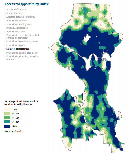
OPCD’s HALA project manager Sara Maxana said proximity to frequent transit nodes was the basis for deciding which urban village to expand, and about a dozen will be expanded. Specifically, the City would expand urban village boundaries to 10-minute walkshed around frequent transit nodes, which is defined as the intersection of two transit frequent bus lines or a light rail station. That definition was set two years ago in the Comprehensive Plan process before several urban villages like Greenwood got a second frequent transit line (with the improvements of Route 45 running along NW 85th Street in that case.)
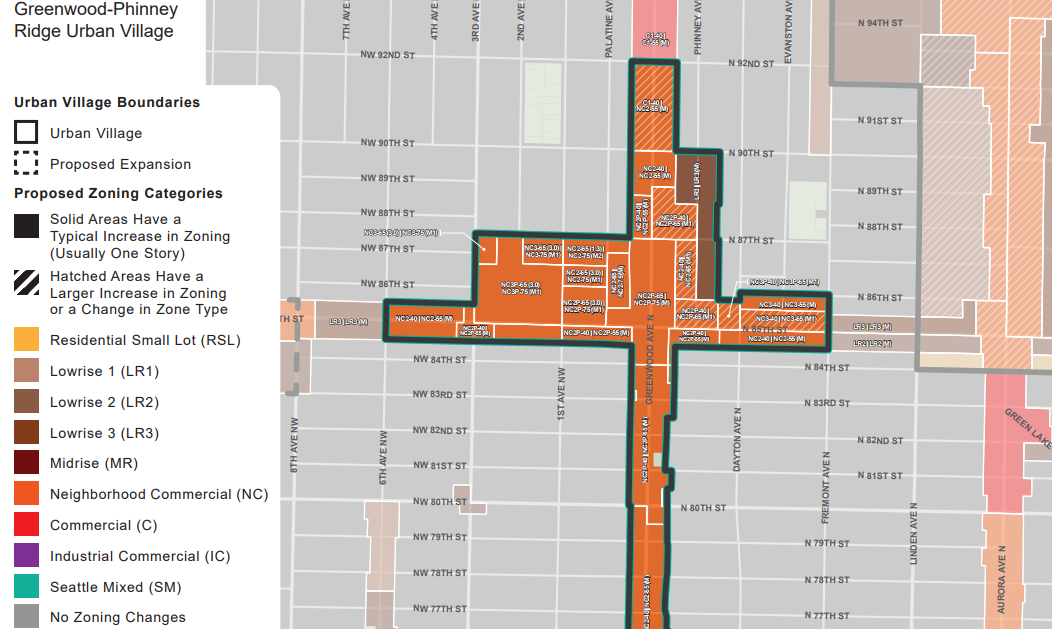
On the other hand, neighborhoods like Crown Hill and Ballard met the definition of a frequent transit node since the RapidRide D Line and Route 40 run though each urban village and met the definition two years ago. Since frequent transit expanded greatly in the last two years, it would behoove the Seattle City Council to expand more urban village boundaries as the continuous work of the Comprehensive Plan continues.
Additionally, five-minute walksheds of transit see heightened M1 and M2 even in high displacement risk neighborhoods, whereas high displacement risk neighborhoods mostly the bare minimum upzone to trigger MHA outside that five-minute transit walkshed. Maxana said OPCD did make some exceptions for properties owned by by affordable housing providers.
A Family-Size Rule for LR1
Another wrinkle to make it into the FEIS proposal was a rule to require buildings with small units (400 square feet and under), to have one two-bedroom apartment (of at least 800 square feet) for every four small units–the goal being to serve to serve families. Today, Lowrise 1 is not seeing many micro-units go in, OPCD senior planning manager Geoff Wendlandt said.
Introducing Residential Small Lot
One new zoning category makes a big debut in the plan: Residential Small Lot or RSL. About 50% of single-family areas getting rezoned go to RSL, said OPCD director of communications Jason Kelly.
RSL allows up to three units per lot with a density limit of one per 2,000 per sq feet lot (rounding at 0.85). RSL’s maximum dwelling unit size is 2,200 square feet, precluding new mansions from going up in RSL zones. A 3,700-square foot lot is large enough for a second unit in RSL zoning. By my calculation, a lot would have to be 5,700 square feet to get a third dwelling unit. Thus, RSL is still modest in scale but a big improvement over existing single-family zoning, which is producing a lot of teardowns for mansions and not much else.
Looking Ahead
The Seattle City Council plans to vote on the Northgate MHA rezone separately from the rest of the urban villages in order to facilitate transit-oriented development plans around the Northgate Link station. The rest of the village will be in one big package expected to be voted on this summer. The council can of course make further tweaks to the package.
We will continue to comb through these nearly 1,500 pages worth of documents and follow-up with more insights. Might take some time!
Main FEIS Document
FEIS Appendices
Draft Environmental Impact Statement Shows Big Possibilities for MHA Rezones
Doug Trumm is publisher of The Urbanist. An Urbanist writer since 2015, he dreams of pedestrian streets, bus lanes, and a mass-timber building spree to end our housing crisis. He graduated from the Evans School of Public Policy and Governance at the University of Washington in 2019. He lives in Seattle's Fremont neighborhood and loves to explore the city by foot and by bike.


