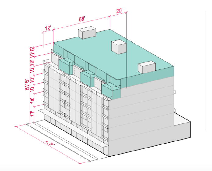
Rezones are on the horizon for many areas in Seattle as part of Mayor Ed Murray’s Housing Affordability and Livability Agenda. Giving an early sneak peek this week, the Office of Planning and Community Development (OPCD) released five draft maps for a handful of urban villages and urban centers slated for the Mandatory Housing Affordability (MHA) rezones. Those rezones are coupled with other increases in development capacity that will allow the City to require new residential and commercial development to contribute toward affordable housing at various levels below the area median income.
OPCD is diligently developing parallel concept proposals that would modify development regulations to further support the rezones. These are tied to dimensional form controls like minimum lot size and density, floor area ratios, height, and setbacks as well as allowed uses. So far these come in nine flavors, which we’ll dive into further below, but additional concepts are presumably forthcoming for zones like Highrise (HR), Commercial 1 and 2 (C1 and C2), and others that are noticeably absent.
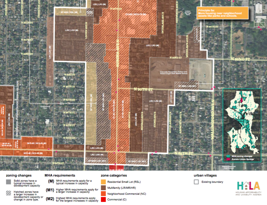
Many readers with a good eye may have gleaned from the draft MHA rezone maps that some zones such as Lowrise 2 (LR2) and Midrise (MR) aren’t really changing in name and wondered “well how is that a rezone?” OPCD is exploring nuanced Land Use Code changes that would modify the regulations for those types of zones, essentially by adding new categories of development standards specific to the MHA zoning variants. So when an LR2 zone gets an M-suffix added to it on the zoning map, the higher intensity version of LR2 development regulations would apply.
In other cases, the draft MHA rezone maps show linear zoning changes that would be made from say an NC-40 zone to NC-55 zone. But even under MHA rezones, the higher zoning type would still be more generous than the parallel zone in the Land Use Code today due to underlying development regulation changes that may be made for MHA variants of those zoning types as well.
It’s also worth mentioning that OPCD has put out rezones that aren’t just linear changes, and instead could be even bigger lifts from say LR3 to MR or C1-40 to NC3-75 with the appropriate M-suffixes. So to make sense of the draft MHA rezone maps, it’s important to understand some of the basic bulk form aspects that may come with them.
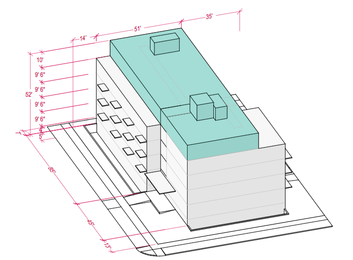
To illustrate this, let’s look at the Lowrise 3 (LR3) zone, a relatively common multi-family residential zone in Seattle. LR3 zones are generally proposed to get a height limit boost from 40 feet to 50 feet and a floor area ratio (FAR) increase from 2.0 to 2.2 as MHA LR3. The current LR3 zones have a sliding scale for maximum FAR, which depends upon factors like the type of use (cottage housing, townhouse, rowhouse, and apartment); whether or not the zone is located in an urban village, urban center, or station area overlay district; and if certain standards are met. It’s not clear how that may or may not change as the OPCD’s concepts for development regulations evolve further. Density maximums are common for most residential uses in the LR3 zone, but can be waived under current code. It appears that the density maximums may go away. OPCD’s concept for the MHA LR1 zone indicates that there would not be a maximum density cap, which suggests that no Lowrise zoning type, including LR3, would be subject to one.
OPCD has laid out a handy crosswalk to highlight this and other considerations in practice. The crosswalk displays a variety of scenarios using sites ranging from 5,000 square feet to 15,000 square feet and different housing types (i.e., rowhouses, and apartments on small and large sites). Running the numbers, OPCD has determined the number of dwelling units, average unit size, number of parking spaces, and gross square footage of development that one might expect under the existing Land Use Code and concept MHA regulations for each development type.
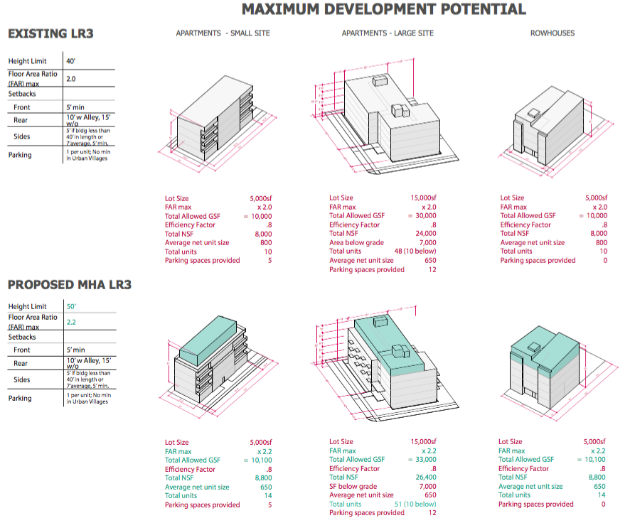
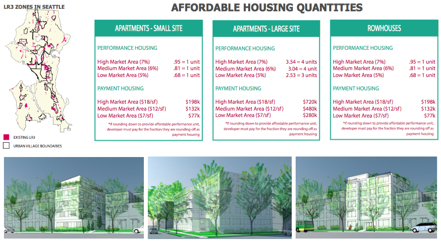
OPCD has also gone a step further by showing where LR3 zones are located, providing renderings of possible developments in context, and evaluating affordable housing quantities under MHA. The latter is especially specific. Tables reflective of each of the above development scenarios derive the number affordable housing units that would have be built or paid for in lieu, depending upon whether the project is located in a high, medium, or low market area.
Comparison of Conceptual MHA Zoning Changes
| Zoning Designation | Max Height | Max FAR | Max Density | Additional Notes |
|---|---|---|---|---|
| RSL | 30' | None | 1 single-family detached dwelling unit per 2,500 square feet; 1 cottage housing dwelling unit per 1,600 square feet | RSL would be revised under MHA, as indicated below |
| MHA RSL | 30' | 0.75 | 1 dwelling unit per 2,000 square feet | Attached townhomes and stacked housing would be added as allowed residential uses; parking requirements would be eliminate in urban villages |
| LR1 | 30' | 0.9-1.2 | Ranges from none to 1 dwelling unit per 2,200 square feet, depending upon use and bonus | LR1 would go MHA LR1 |
| MHA LR1 | 30' | 1.2; 1.3 townhouse or rowhouse | None | N/A |
| LR2 | 30' | 1.0-1.3 | Ranges from none to 1 dwelling unit per 1,600 square feet, depending upon use and bonus | LR2 would go to MHA L2 |
| MHA LR2 | 40' | 1.4 | None | N/A |
| LR3 | 40' | 1.1-2.0 | Ranges from none to 1 dwelling unit per 1,600 square feet, depending upon use and bonus | LR3 would go to MHA L3 |
| MHA LR3 | 50' | 2.2 | None | N/A |
| MR | 60' base; 75' bonus | 3.2 base; 4.25 bonus | None | MR would go to MHA MR |
| MHA MR | 75'; 80' proposed for additional height | 4.5 | None | N/A |
| NC-30 | 30' | 2.5 | None | NC-30 would go to MHA NC-40 |
| MHA NC-40 | 40' | 3.0 | None | N/A |
| NC-40 | 40' | 3.25 | None | NC-40 would go to MHA NC-55 |
| MHA NC-55 | 55' | 3.75 | None | N/A |
| NC-65 | 65' | 4.75 | None | NC-65 would go to MHA NC-77 |
| MHA NC-75 | 75' | 5.5 | None | N/A |
| NC-85 | 85' | 4.5 for single use; 6.0 for mixed-use | None | NC-85 would go to MHA NC-95 or MHA NC-100 |
| MHA NC-95 | 95' (100' for NC-100) | 5.0 for single use; 6.25 mixed-use | None | N/A |
Most of the key caveats have been identified in the table above, but it’s worth mentioning that the NC zones have higher standard maximum FAR allowances when located in a station area overlay district and a development uses incentive zoning. Some of the FAR allowances are more generous than what OPCD has identified in MHA, which likely means some sort of reconciliation will be required.
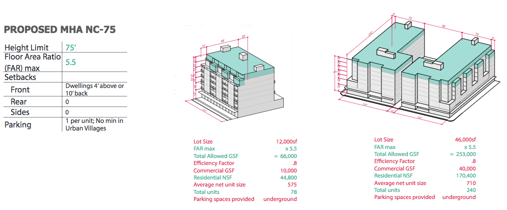
The City’s Land Use Code is, of course, much more complex than just these base development regulations and individual development proposals will almost always be affected in more specific ways, but this at least gives a starting framework to understand how the MHA rezones and subset of development regulations might work.
Seattle OPCD – Draft MHA Zoning Concepts by The Urbanist on Scribd
Stephen is a professional urban planner in Puget Sound with a passion for sustainable, livable, and diverse cities. He is especially interested in how policies, regulations, and programs can promote positive outcomes for communities. With stints in great cities like Bellingham and Cork, Stephen currently lives in Seattle. He primarily covers land use and transportation issues and has been with The Urbanist since 2014.

